
Every summer, the world’s forests face a severe test. Rising temperatures, drought, and human error have turned wildfires from an environmental concern into a global crisis. But the new era comes with new solutions: Unmanned Aerial Vehicles (UAVs), better known as drones.
While traditional firefighting teams and aerial units remain effective in many cases, challenges like inaccessible mountainous areas, nighttime operations, and rapidly shifting fire lines make the job even harder. This is where drones step in, from the skies, they offer high-tech, risk-free, fast, and flexible support to combat wildfires.
Drones Don’t Just Fly — They Manage Fires
Today, drones carry out a wide range of missions in wildfire response: from early detection and real-time mapping to guiding intervention strategies. Equipped with thermal cameras, many drones can provide critical data about the location, direction, and intensity of fires, even in low-visibility conditions caused by smoke.
In some countries, drones go beyond observation; they’re actively involved in extinguishing fires.
United States – California Forests | Lockheed Martin Indago 3/4 & DJI Matrice 300 RTK
California’s Department of Forestry and Fire Protection (CAL FIRE) uses Lockheed Martin’s Indago 3 drones for fire surveillance. With a flight time of up to 70 minutes, thermal sensor integration, and a low noise profile, this drone plays a crucial role in identifying fire ignition points. DJI’s Matrice 300 RTK is used for mapping fire lines and guiding ground teams.

Australia – Thermal Surveillance and Wildlife Rescue | Parrot Anafi Thermal & C-ASTRAL Bramor C4EYE
Following the devastating “Black Summer” fires of 2019–2020, Australia embraced drone technology through both public institutions and NGOs. The Parrot Anafi Thermal helps locate surviving animals, while long-range UAVs like the Bramor C4EYE analyze fire spread over vast terrains.

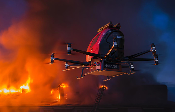
China – Flame-Extinguishing Drones | EHang 216F
Chinese company EHang developed the EHang 216F, a drone capable of vertical take-off and active firefighting. It can spray water on fires in high-rise buildings. Additionally, small “Fire Eye” drones continuously scan forest areas prone to ignition, serving as an early warning system.
Canada – Advanced Data Collection | SkyRanger R70 (FLIR Systems)
Canada’s Forest Service deploys SkyRanger R70 drones to analyze not just fires, but also meteorological changes during wildfire events. These drones report real-time shifts in wind direction, helping ensure firefighter safety.

Spain – Advanced Coordination Systems | Alpha Unmanned Systems A800
Spain uses Alpha A800 UAVs, especially in rural fire zones. With a flight duration of up to 2 hours, these drones provide continuous data streams to firefighting teams. In hard-to-navigate areas, they transmit live footage to command centers via radio communication.

Beyond Extinguishing: A Preventive Role
Can fires be stopped before they even start? With drones, yes. New-generation drones integrated with AI-supported systems can create “risk maps” by analyzing areas prone to fire. In some countries, power lines or fields where stubble burning occurs are constantly monitored using such systems.
The Future Is in the Sky
The fight against wildfires is no longer confined to the ground—it now soars into the skies. Drones not only prevent disasters from escalating but also protect the environment without putting human lives at risk.
It’s clear: The firefighters of the future may not carry hoses, but propellers. Today’s wildfire warriors are no longer just brave humans, but also robotic sentinels gliding through the skies.